Brunswick Valley Flood History...
Menu
PRESS
LATEST
UPDATES
MEDIA FILES
Current Updates
From Date May 12, 2017 to Now
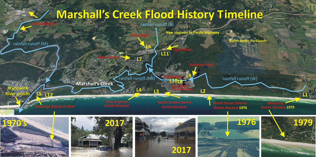
KEY:
Flood History Location Points (see yellow numbering on map above... click to enlarge);
L1 - Wooyung Flood Outlet still closed at 1979. Flood outlet aerial photos taken in 2005.
L2 - North Ocean Shores Flood Outlet closed 1976.
L3 - South Golden Beach Flood Outlet closed 1954.
L4 - New Brighton Flood Outlet closed 1997.
L5 - Reading’s Bay Rock Wall built 1970’s. Professor Warners Report on siltation behind rock walls.
L6 - Billinudgel Main Street … high level flooding 2005, 2017.
L7 - Ocean Shores homes flooded 2005, 2017.
L8 - Levee Bank at South Golden Beach built 1989 & Flood Pumps installed 2006.
L9 - Kallaroo Bund. Culverts added in 2008.
L10 - Helen St Footbridge built on flood plain in 2010.
L11 - North Ocean Shores Sport Field (Soccer) built on flood plain in 2016.
L12 - Former site of Sheltering Palms Hamlet 1974.Background:
My name is Jim Mangleson and have been a resident of Byron Shire since 1972.
I have researched and documented man made changes to the floodplain from Wooyung to Brunswick Heads since 1887.
This research has uncovered drastic changes to the natural drainage system and liability for the flooding by both Government and Local Government Agencies as well as Rutile miners in the late 50’s.
I am the only foundation Community representative of the original Marshalls Creek Flood Plain Management Plan Committee that has been running now for over 40 years. more infoThe Summary Story: click here
Below are the ‘man-made’ obstructions in the timeline of events from Wooyung to
Brunswick Heads.
1887 - Survey map of Wooyung showing natural outlet to ocean. (L1)
1900 - Crabbes Creek Drainage Trust district map showing the cane drain lines into outlet. (L1)
1947 - Wooyung outlet photo compared to 1887 survey map and 1900 district map. There were natural outlets at North Ocean Shores & Wooyung. Developers were ordered by Council to close the North Ocean Shores outlet in 1976.
1951 - Floating Dredge for sand mining in outlet at Wooyung. (L1)
1954 - Pre development photo of Golden Beach showing 2 outlets to Marshalls Creek including location at Helen Street. (L3)
1958 - Aerial photo shows Helen Street Outlet being closed. Note: Beach Terraces now being destroyed by escaping floodwaters between Golden Beach and New Brighton (L3)
1972 - Aerial photo of the Wooyung outlet. It was closed after the Sand Miners removed their dredge from the outlet. (photo used in the North Byron Shire Flood Survey 2018)
1972 - PWD Report admits effect at Sheltering Palms was “Dramatic” Cylone Daisy.
1972 - “New Brighton -1972 Daisy flood happening and the floodwaters breaking through the sand dunes, – just north of New Brighton! At this time, our family lived at Casons Road (as we knew it, not Lane), New Brighton. About an inch for floodwaters to be flooding our home. Later, to my AMAZEMENT, looking out the kitchen window – saw the floodwaters flowing NORTH (total change of DIRECTION) – and with speed. WHAT HAS HAPPENED was my wonder? By the time myself and our 2 children (as my husband was out helping) were able to leave our home and the water was gone from the road, we headed for ‘the action’ – crowds of people walking NORTH to see what was happening! To our shock, wonder, amazement, AWE, - what did we see .... ROARING RAPIDS ... WIDE, MASSIVE, RAPIDS ROARING OUT INTO THE OCEAN! We were just ‘numb’ with the awesomeness of what we were witnessing! A BREATHTAKING SIGHT!! Roared out to sea for hours – just north of New Brighton! This has not been recorded in the high flood/cyclone events. WHAT A SIGHT THAT WAS!!
That break-through saved many a home from being flooded that day in the event of cyclone Daisy!!
Jillian Spring, Billinudgel. October 2019”
1972 - Newspaper article confirming at the peak, the flood broke through beach terraces and escaped into the sea.
1974 - Flood Outlets at North Ocean Shores still open. The outlets were closed in 1976.
1974 - Flood March Cyclone Wanda. Canefields drain through Ocean Shores flood outlet and canal because rutile miners filled in Wooyung outlet. (L1, L2, L9)
1974 - Sheltering Palms destroyed.
1976 - July BSC orders developers to close flood outlet. (L2)
1976 - September Council accepts liability for flood increase by ordering closure. (L2)
1976 - Developers fill in outlet after Council accepts liability. (L2)
1978 - Council begin beach scraping to fill in erosion and old flood outlets through the frontal dunes.
1979 - Wooyung outlet closed.
1982 - Deputy Premier warns Council of their liability and the area will flood.
1984 - Public Works Dept engineer warns Council's Flood Consultants if outlet is blocked it will raise flood levels by 1.5 m and it should be resolved as a matter of priority.
1985 - BSC letter to developer acknowledging numerous warnings from Government over breach of DA conditions and bond held by them for construction.
1986 - Council stripped of planning powers. Jim Waugh appointed administrator.
1986 - Waugh appoints Engineer Frank Cranston to check Deed of Agreement for Ocean Shores and warns Council of their liability. Censored report given to public deleting that liability and previous warnings.
1987 - Mothers Day Flood with severe flooding and no bund at Kallaroo Circuit . Council refuse to re-open outlet after urgent request from SES wardens. (L2) See video opposite Channel Nine News. Tweed cane fields drain though canals no Kallaroo Circuit bund in place. (L9)
1987 - South Golden Beach Progress Association flood meeting minutes.
1987 - photo of flood outlet still closed (L2), flood levels higher at New Brighton.
1988 - Marshalls Creek Preliminary Study of Bed Sediments & Stability (Robin F Warner report for Webb, McKeown and Associates October 1988) Note: No 5 - more effective flood drainage.
1988 - South Golden Beach flood development plan.
1988 - Council admits SGB levee (L8) will raise flood heights outside the levee if built higher than 2.68 Metres AHD and residents outside the levee will object to increase in flood heights caused by the levee and also on page 2 of the report higher protection can only be achieved by dredging of Marshall's Creek.
1990 - Letter from Council confirming bridge must be built at Kallaroo Circuit and bond still held for its construction. (L9)
1991 - Alderson confirms outlet would now make a “significant” difference in flood heights. Email from Alderson confirming figures (L2)
1992 - Flood Committee expresses concern at impartiality of consultants appointed to do Flood Study briefing environmental organization before meeting Committee members and the opposition to a Council member opposed to dredging being on the Committee.
1992 - Council build Community Centre hall on site of old flood outlet at Golden Beach. (L3)
1995 - Byron Shire Election Poll newspaper article to open outlets and dredge river & creeks.
1997 - Council adopts plan which states flood heights cannot be reduced despite 1991 letter from Alderson stating "significant difference" in lowering flood levels.
2001 - Letter from Don Page MP Member for Ballina asked the Minister to consider a public inquiry into the Marshalls Creek Flood Plain costings & projects.
2001 - Call for an inquiry into flood management in the north of the shire.
2005 - Major flood (June 30 see SGB video) and cane fields suffer because bund now restricts flow through to canal and flood water overflows into Golden Beach causing major damage again. Insurance companies refuse to pay.
2006 - Cane farmers begin legal action against Byron Shire Council.
2006 - Byron Shire News article on the $1.3M Flood Management Plan.
2008 - Tweed Council enlarges culverts in bund at a cost of $713,000. (L9)
2009 July - New Joint Study between Tweed and Byron Councils. Summary clearly identifies common link of natural connections in the common floodplain despite claims from Committee green activist members.
2010 - Council builds footbridge with pylon supports in canal at a cost of $904,000 (original quote $80,000). (L10)
2016 - Council fills in High Hazard Flood Liable land at North Ocean Shores to construct soccer field. (L11)
2016 - Council ignores warning from Flood Consultants (BMT WBM) Golden Beach will flood even in a minor event if there is a failure of the pump system.
2016 - New Flood Plain Study by WMA Water undertaken by Byron Council. Plan area now omits the common area of Billinudgel Creek and old outlet ordered closed by Council. Both Councils TWEED AND BYRON have now allowed natural outlets to the Ocean to be closed.
2016 September - Foundation member of Flood Plain Committee Jim Mangleson representing the largest population base in the Shire now not re-elected to Flood Plain Committee and Ocean Shores has no Committee members residing in Ocean Shores.
2017 - Cyclone Debbie Rain Event March. New Brighton, Billinudgel, Mullumbimby
2017 - Billinudgel floods higher than ever (L6). Pumps fail behind levee banks (L8) at Golden Beach and insurance refused for residents.
2017 - Readings Bay internal walls with constricted minature outlet at western end.
2017 - Government does not declare area a “Natural” disaster.
2018 - New Consultants WMA Water undertake extensive Community Survey in 2018.
2018 September - ECHO reports huge community anger at response to survey from residents for not carrying out remedial flooding measures of reopening the Flood outlet ordered closed by Council in 1976, Dredging Marshalls Creek, Remove internal rock wall in Readings Bay which is blocking the only remaining natural outlet to the ocean.
2018 September - Council NOTES only the Report and one sitting Councillor casts doubts on Community response as do several Green Committee members who do not reside in the flooded North.
2019 - Letter from Col Loomes Surveyor - click here
2020 February - Council calls for response from Community to Draft Plan.
2020 - OSCA Flood Letter & Submission Objection responses.
Documents and Photo FACTS
compiled by
Jim Mangleson
Foundation Community Representative of the
Marshall's Creek Flood Plain Management CommitteeHistorical FACTS Researched by
Frank Mills OAM
Former Byron Shire Councillor
Former Chairman of OSCA Inc.
Committee Representative for BV Historical Society
Representative on the Abi Group - Member of the Heritage Management Plan
Definition of TRUTH: (Pocket Macquarie Dictionary)
1. something which is true or actual: to tell the truth.
2. agreement with fact or reality: the truth of a statement
3. an indisputable fact, principle, etc: mathematical truths
4. genuiness, reality, or actual existence.
5. honesty or integrity.
6. in truth, in fact, in reality; truly.

Charlie
O Donnell
Interview 1984
Channel Nine News 1987
South Golden
Beach
Food June 2005
The Snapshot of Facts:
Readings
Bay Outlet
blocked by Rock Wall 1970
Sheltering
Palms Hamlet
destroyed by Cyclone
Wanda 1974
North Ocean
Shores
Flood Outlet closed 1976
Wooyung
Flood
Outlet closed 1979
Mother's Day Flood 1987
Canal blocked
by bund
instead of a bridge 1987
Levee Bank
built at
South Golden Beach 1989
Helen Street
Flood
Outlet blocked by
Community Centre 1992
Misleading
Floodplain
Management report 1992
New Brighton
Flood
Outlet closed 1997
Flood Event 2005
Footbridge
2010
& Sport Field 2016
built on floodplain
Cyclone
Debbie rain
event 2017
Website Provider Disclaimer. While every effort has been made to ensure the information on this site is correct, it is not always possible to achieve complete and total accuracy.
Therefore we accepts no responsibility for any loss or damages which may occur to any persons as a result of information obtained from this site.